California
Related: About this forumCalifornia storm to bring strong winds, widespread rain to parts of state
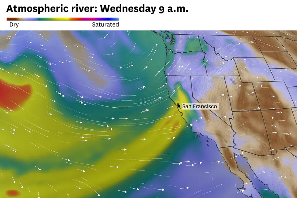
Atmospheric River: Wednesday, 9:00 AM
San Francisco Chronicle / 11-3-25
Wet weather is forecast to return this week. Widespread rain and the strongest winds so far this season are predicted in the Bay Area, North Coast, Sacramento Valley and Sierra Nevada as an atmospheric river-fueled storm sweeps through the region.
The parent storm, a broad low-pressure system over the Pacific Ocean, will be nearly 1,000 miles northwest of San Francisco, but its counterclockwise spin will guide a long plume of water vapor from near Hawaii toward California. Scientifically, this is known as an atmospheric river, a common feature of West Coast storms.
Rain will begin Monday afternoon near Eureka as the atmospheric river makes landfall. As the water vapor encounters Northern California’s steep coastal mountains, it will be forced to rise and condense into liquid. Moderate rainfall will ensue, and Del Norte, Humboldt and Mendocino counties could pick up 2 to 5 inches of rain through Wednesday — a good soaking but nothing remarkable for that part of the state in November.
In the Bay Area, rain chances increase Tuesday, primarily north of the Golden Gate as the atmospheric river slides southward. Sonoma and Marin counties have the best chance of getting soaked Tuesday, but drizzle cannot be ruled out in San Francisco.
https://www.sfchronicle.com/weather-forecast/article/california-storm-atmospheric-river-rain-wind-21134003.php
• Wednesday is forecast to be the stormiest day of the week.
• Expect widespread rain and blustery winds. -- Bay Area gusts up to 55 mph along the coast and 40 mph inland.
• A half-inch of rain is forecast in San Francisco and Oakland, with less in the South Bay and more in the North Bay.
 = new reply since forum marked as read
Highlight:
NoneDon't highlight anything
5 newestHighlight 5 most recent replies
= new reply since forum marked as read
Highlight:
NoneDon't highlight anything
5 newestHighlight 5 most recent replies


Auggie
(32,710 posts)
PufPuf23
(9,665 posts)Forecast for my location (in Klamath canyon 30 crow miles from Pacific NE of Eureka)
What
South winds 25 to 35 mph with gusts up to 70 mph expected.
Where
Humboldt Interior, Del Norte Interior, and Southwestern Humboldt. The highest winds will be over the higher terrain.
When
From 2 PM Tuesday to 2 PM PST Wednesday.
Impacts
Damaging winds will blow down trees and power lines. Widespread power outages are expected. Travel will be difficult, especially for high profile vehicles.
I have a medical appointment 2 PM tomorrow that requires an 80 mile drive. May be an adventure.
There are also localized flood warnings. My concern is rock slides and trees falling on the highway. Expect to lose power at my home.